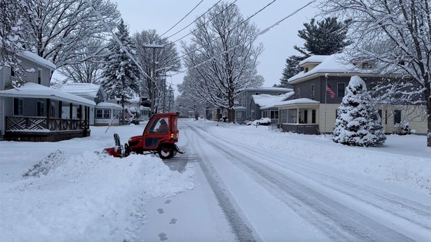
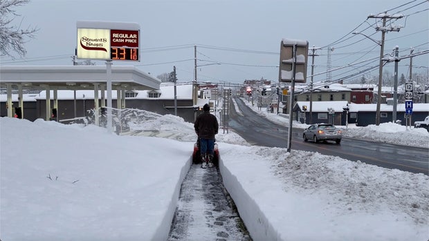
The first major snowstorm this season blanketed parts of New York, Pennsylvania and Michigan over the weekend, in the midst of hectic post-Thanksgiving travel and discount shopping sprees. Forecasters expected very cold temperatures and heavy snow to persist through the beginning of the week and potentially pose dangers to travelers in the Great Lakes, Plains and Midwest regions.
The snow storm led to an emergency declaration in parts of New York and a disaster declaration in Pennsylvania, with officials warning of dangerous conditions for Thanksgiving travelers returning home.
A blast of Arctic air brought bitter temperatures of 10 to 20 degrees Fahrenheit below average to the Northern Plains, the weather service said, prompting cold advisories for parts of North Dakota. Frigid air was expected to move over the eastern third of the U.S. by Monday, with temperatures about 10 degrees below average.
Nearly 2 feet of snow fell in parts of New York, Ohio and Michigan and 29 inches was recorded in Pennsylvania’s northwestern tip. By 7 a.m. ET Saturday, the weather service in Buffalo reported between a foot and 18 inches of snow had already fallen in towns and villages around Lake Ontario and Lake Erie, with 24 inches recorded in one place near the Pennsylvania border. More snow had accumulated throughout the region by the early afternoon, forecasters said.
There was more snowfall to come Sunday, according to the weather service, which warned areas east of Lake Erie and Lake Ontario could potentially receive one or two feet of snow. In Jefferson County, forecasts showed a rate of 3-4 inches of snowfall per hour would continue throughout the day.
Snow was also forecast to return Sunday to Cleveland, and weather service meteorologists in the Ohio city said they expected 6 to 18 inches of new snow to accumulate in an area stretching from there to the Pennsylvania-New York state line by through Tuesday.
The National Weather Service said Sunday that “travel could be difficult to impossible” in places where ongoing snowfall is forecast through the beginning of the week.
“Snow will increase in intensity today and slowly spread south across much of the primary snow belt,” said the weather service in Cleveland Sunday morning. Forecasters noted that snowfall would happen periodically through Tuesday morning, although heavy accumulation was expected Sunday as they predicted snowfall rates of more than an inch per hour in both Ohio and Pennsylvania.
Gene J. Puskar / AP
In an alert on Saturday afternoon, the weather service had said the heaviest snow totals were expected “downwind of lakes Erie and Ontario, affecting areas from northeast Ohio, far northwest Pennsylvania, western New York State and portions of northwest New York state.”
In a phone interview Saturday with WWNY-TV, New York Gov. Kathy Hochul told the Associated Press that the state prepared for the storm for days by deploying snowplows and thousands of workers and consulting with utility providers. She also dispatched personnel from other parts of the state to assist.
“I know it’s something they’re all accustomed to and they can handle, but I want to let them know we are there with reinforcements and to make sure everyone can travel safely, especially over this really busy holiday weekend,” she said.
Pennsylvania Gov. Josh Shapiro signed a disaster emergency proclamation and said parts of Erie County in the northwest received nearly 2 feet of snow with more expected through Monday night.
Pennsylvania State Police responded to nearly 200 incidents during the 24-hour period from 6 a.m. Friday to 6 a.m. Saturday, officials said. Authorities closed part of I-90 in Pennsylvania and westbound lanes of the New York Thruway heading toward Pennsylvania.
Cara Anna / AP
The city of Erie, Pennsylvania, said travel was limited to emergency responders and essential employees and cases of medical emergency until further notice due. The snow and slippery conditions resulted in stuck vehicles blocking intersections and streets. Residents were urged to shelter in place and allow crews to clear neighborhoods.
With parts of some roads impassable in northwestern Pennsylvania, scores of travelers took refuge in the lobby and hallways of a Holiday Inn near I-90. Hotel staffer Jeremiah Weatherley said workers opened the conference room and gave them blankets.
“They just showed up, and we don’t want to turn people away,” he said.
In Buffalo, officials with the NFL’s Bills sought stadium snow shovelers for the season, including ahead of Sunday night’s game against the San Francisco 49ers. The team said it would pay $20 per hour and provide food and hot drinks.
Parts of Michigan were battered by lake-effect snow, which happens when warm, moist air rising from a body of water mixes with cold dry air overhead. Bands of snow rolling off Lake Superior buried parts of the Upper Peninsula under 2 feet (61 centimeters) or more, said Lily Chapman, a meteorologist with the National Weather Service office in Marquette, Michigan.
There were 27 inches of snow just northeast of Ironwood, in the Upper Peninsula’s western reaches, and another 2 feet in Munising, in the eastern area, she said.
Lake-effect snow could add more than a foot over the eastern Upper Peninsula through Monday morning, with 6 to 10 inches or higher to the west, Chapman said.
Cara Anna / AP
Gaylord, Michigan, received 24.8 inches of snow Friday, setting a new single-day record for the city in a region dotted by ski resorts, said Keith Berger of the weather service’s Gaylord office. The previous record of 17 inches was set March 9, 1942.
The snowfall was good news for Treetops Resort, which features 80 acres of ski hill terrain among its 2,000 acres. It boosted the base that snowmaking machines will increase before the resort’s season opening next weekend, Recreation Director Doug Hoeh said.
“Obviously when you get that much snowfall, it’s great for the snow hills, but it’s bad for the parking lots, so we’re kind of digging out,” Hoeh said.


